A review of ocean-atmosphere interactions during tropical cyclones in the north Indian Ocean
Tropical cyclones derive their source of energy—heat and moisture—from the warm waters of the ocean. As such, their genesis, development, intensity, and track are very much linked to the ocean conditions. As the cyclone forms, its intensity and path affect the ocean conditions also. Though there have been a lot many studies looking into various aspects of cyclones, these have remained scattered, and a comprehensive overview has been lacking. Climate change has brought in new challenges and exposed gaps in observation networks and forecasts too.
In this review article, we bring together all these studies and provide a comprehensive review, with updated and extended datasets. We highlight the advancement in research in terms of ocean-atmosphere interaction during cyclones in the north Indian Ocean and identify the gap areas where our understanding is still lacking.
Cyclones in the Indian Ocean
The north Indian Ocean accounts for 6% of the global tropical cyclones annually. Despite the small fraction of cyclones, some of the most devastating cyclones have formed in this basin, causing extensive damage to the life and property in the north Indian Ocean rim countries.
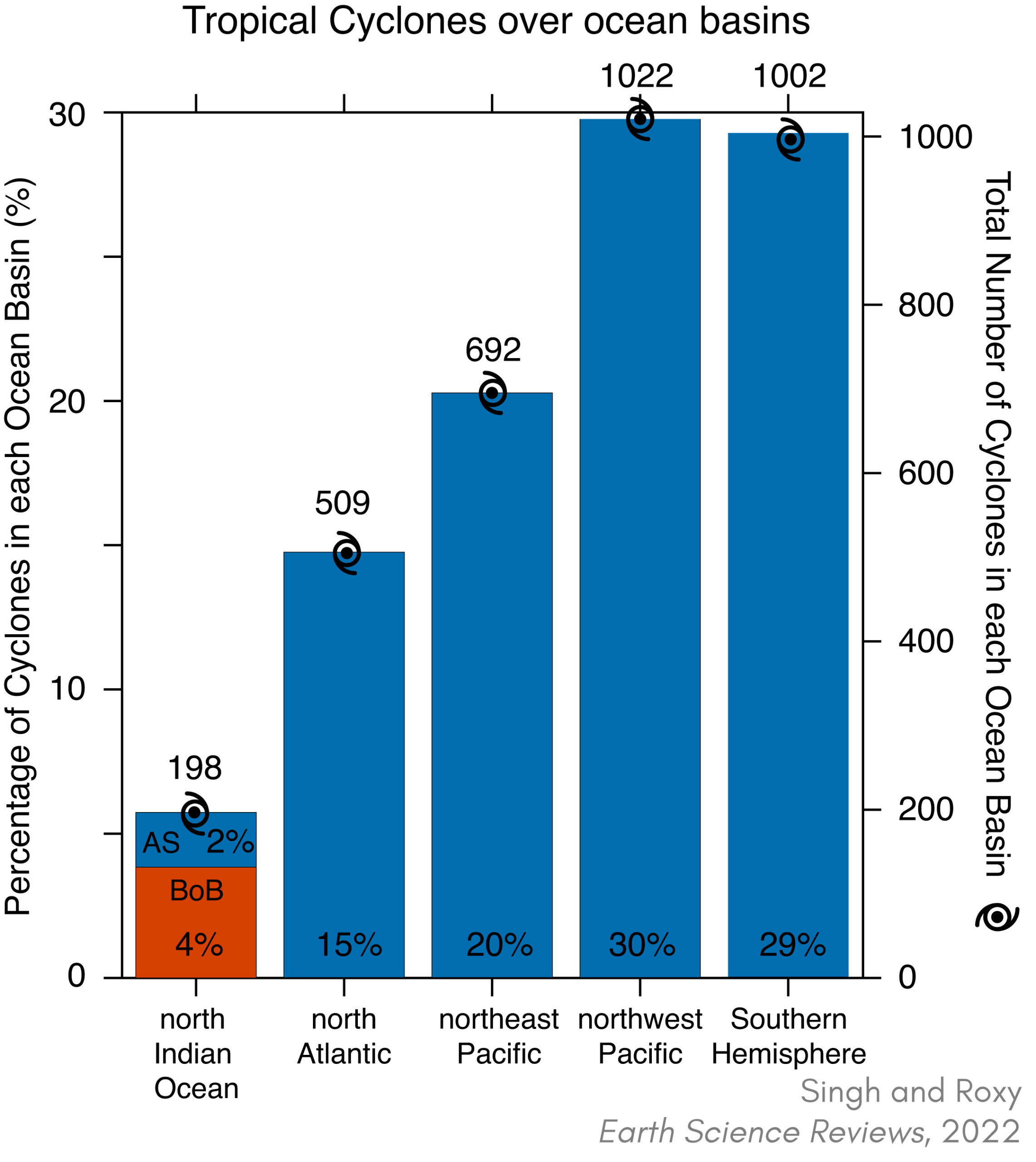
Percentage and the total number of cyclones in each ocean basin, during the period 1980-2019. 4% of total cyclones occur in the Bay of Bengal and less than 2% occur in the Arabian Sea. The total number of cyclones in the north Indian Ocean is less than 6% only, but accounts for more than 80% of the global fatalities due to cyclones.
Ocean-cyclone-atmosphere interactions over the north Indian Ocean
Ocean-atmosphere interaction during cyclones in the north Indian Ocean is a two-way process. High sea surface temperatures (SSTs) of magnitude 28–29°C and above provide favorable conditions for the genesis and evolution of cyclones in the Arabian Sea and the Bay of Bengal. This is why cyclones always form over the warm pools (where SSTs are always larger than 28°C) of the tropical oceans.
On the other hand, cyclones induce cold and salty wakes. Cyclone-induced cooling depends on the translation speed of the cyclone, wind power input, ocean stratification, and the subsurface conditions dictated by the ocean eddies, mixed layer, and the barrier layer in the north Indian Ocean. The average cyclone-induced SST cooling is 2–3°C during the pre-monsoon season and 0.5–1°C during the post-monsoon season. This varying ocean response to cyclones in the two seasons in the Bay of Bengal is due to the difference in the ocean haline stratification, whereas, in the Arabian Sea it is due to the difference in cyclone wind power input and ocean thermal stratification.
More details of the ocean-cyclone interactions are summarized in the schematic below.
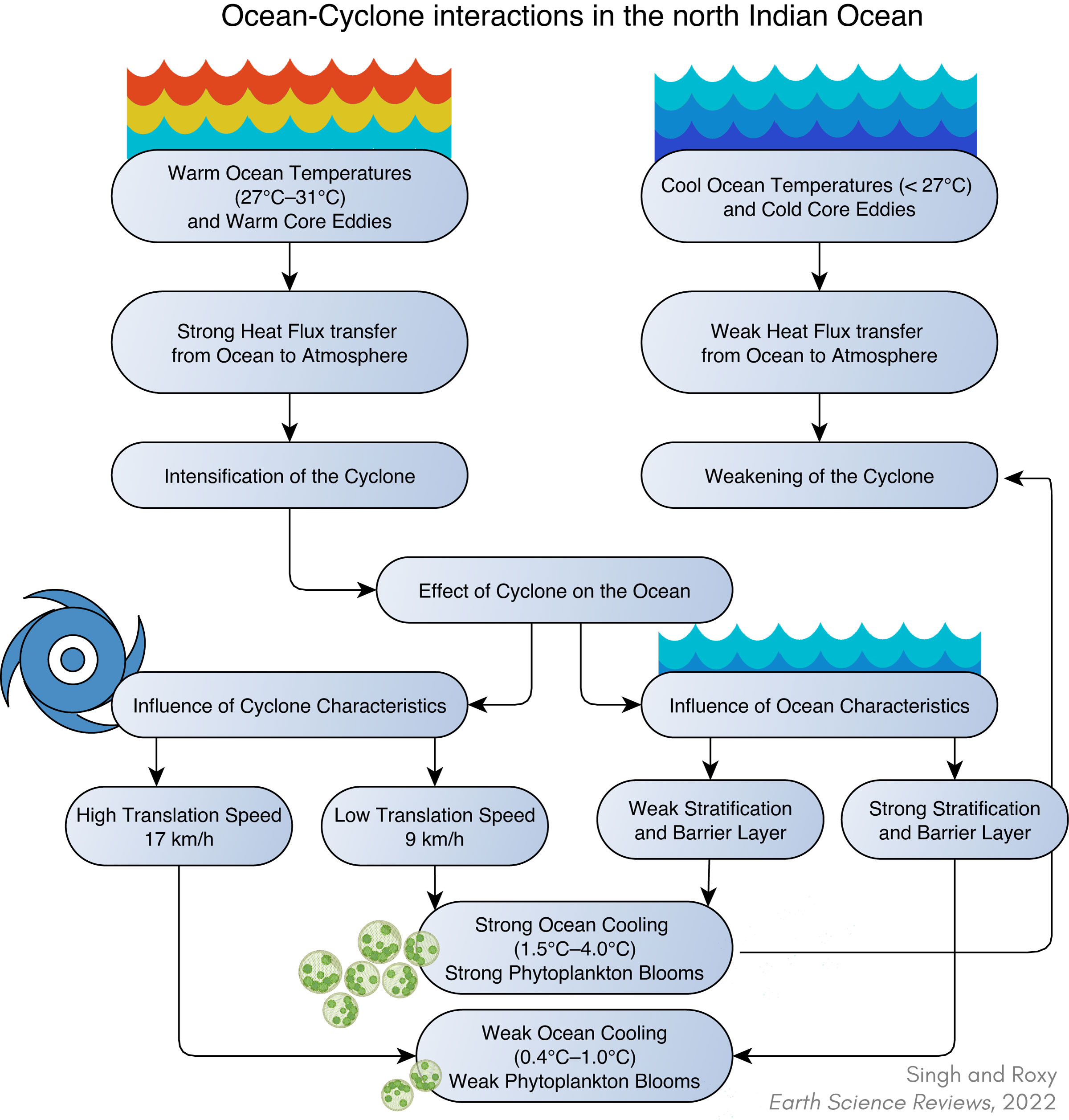
Ocean-cyclone interactions in the north Indian Ocean. Quantification of the ocean temperatures, translation speed, and ocean cooling is based on the studies discussed in this review.
The oceanic response to cyclones is asymmetric due to the asymmetry in the cyclone wind stress, cyclone-induced rainfall, and the dynamics of the ocean inertial currents. The cyclone-induced wake is salty and is the saltiest in the Bay of Bengal among all the ocean basins. The physical response of the ocean to the cyclone is accompanied by a biological response also, as cyclones induce large chlorophyll blooms in the north Indian Ocean that last from several days to weeks.
More details of the asymmetry in the ocean-cyclone interactions are summarized in the schematic below.
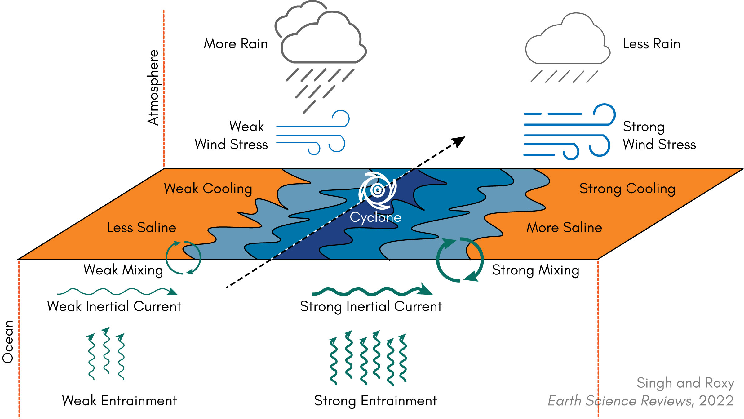
Asymmetric ocean-cyclone-atmosphere interactions over the north Indian Ocean.
Climate Change
Sea surface temperatures (SSTs) leading to cyclogenesis in the Arabian Sea are 1.2–1.4°C higher in the recent decades, compared to SSTs four decades ago. Rapid warming in the north Indian Ocean, associated with global warming, tends to enhance the heat flux from the ocean to the atmosphere and favor the rapid intensification of cyclones. Monitoring and forecasting rapid intensification is a challenge, particularly due to gaps in in-situ ocean observations. Changes in ocean-cyclone interactions are emerging in recent decades in response to Indian Ocean warming, and are to be closely monitored with improved observations since future climate projections demonstrate continued warming of the Indian Ocean at a rapid pace along with an increase in the intensity of cyclones in this basin.
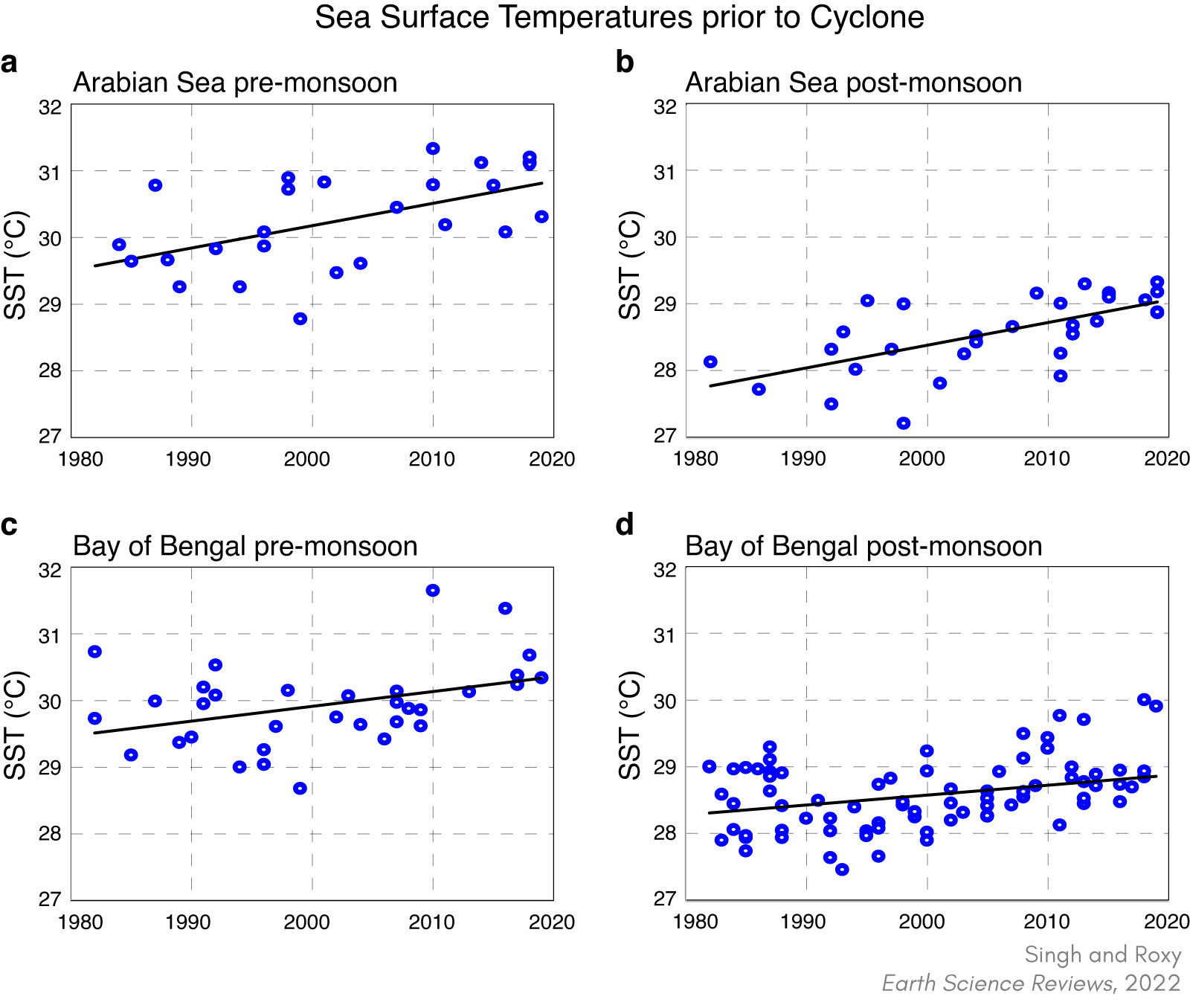
SSTs prior to cyclogenesis—for (a) Arabian Sea pre-monsoon, (b) Arabian Sea post-monsoon, (c) Bay of Bengal pre-monsoon and (d) Bay of Bengal post-monsoon. The total SST change over the Arabian Sea during 1982–2019 is 1.4°C in the pre-monsoon and 1.2°C in the post-monsoon season. Over the Bay of Bengal, the observed change in SST is 0.8°C in the pre-monsoon and 0.5°C in the post-monsoon.
Rapid ocean warming means rapid intensification of cyclones.
Rapid warming in the north Indian Ocean, associated with global warming, tends to enhance the heat flux from the ocean to the atmosphere and favor the rapid intensification of cyclones. For example, Cyclone Amphan intensified from a Category-1 cyclone (about 100 km/hr) to a Category-5 cyclone (about 250 km/hr) in less than 24 hours. Monitoring and forecasting rapid intensification is a challenge, particularly due to gaps in in-situ ocean observations. The quick intensification means that it does not provide sufficient time for evacuation and disaster management on the ground.
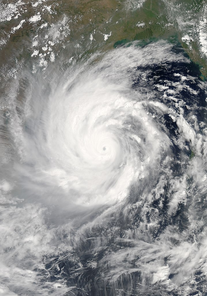
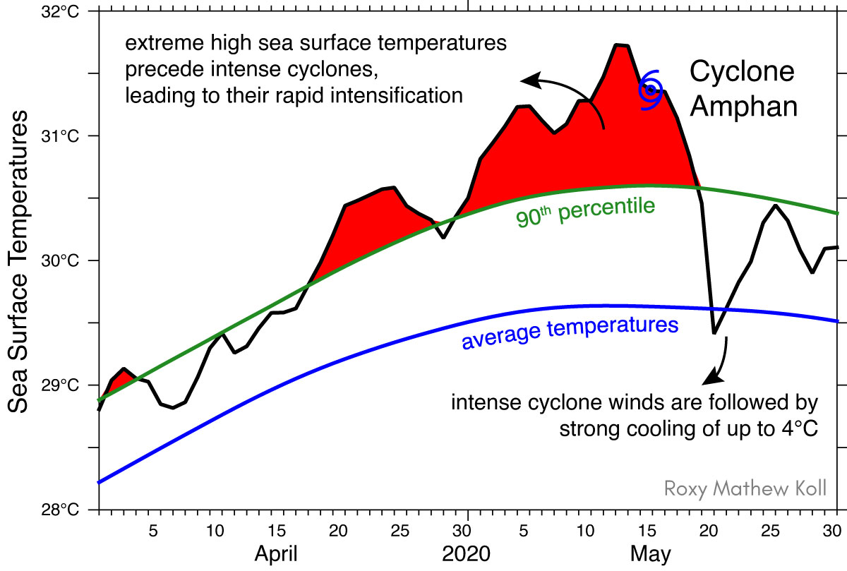
Cyclones are intensifying rapidly due to warming oceans. Monitoring and forecasting the rapid intensification of cyclones is a challenge. Cyclone Amphan intensified from a Category-1 cyclone (about 100 km/hr) to a Category-5 cyclone (about 250 km/hr) in less than 24 hours.
The intensity of cyclones has increased in the Arabian Sea by 20–40%. During the last four decades, the maximum intensity of cyclones has increased by 40% (from 100 km/hr to 140 km/hr), in the Arabian Sea, during the pre-monsoon season (April–May). The Arabian Sea during the post-monsoon season (October–December) has witnessed a 20% increase in the intensity (from 100 km/hr to 120 km/hr). As a result, the total energy used up by a tropical cyclone during its lifetime (known as the accumulated cyclone energy) has also gone up. The changes in the Bay of Bengal are not significantly large.
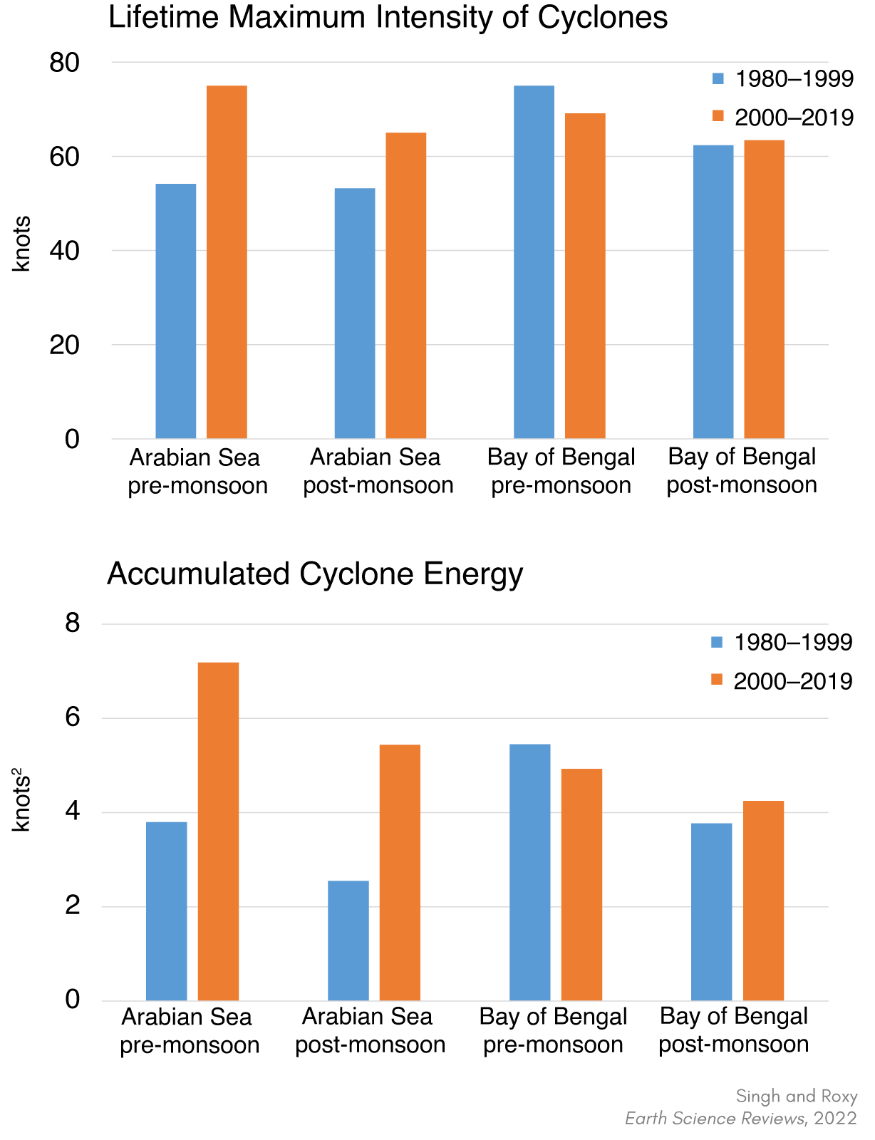
Lifetime maximum intensity of cyclones (knots) and accumulated cyclone energy (knots2) during the period 1980–1999 (blue bars) and 2000–2019 (orange bars) in the Arabian Sea and the Bay of Bengal basin during the pre-monsoon (April–May) and post-monsoon (October–December) seasons. The data shows that the intensity of cyclones in the Arabian Sea increased by 20% (post-monsoon) to 40% (pre-monsoon).
In the north Indian Ocean, every 4th cyclone during the pre-monsoon season intensifies to a severe cyclone of category 3 or more (wind speed > 175 km/hr) and every 7th cyclone in post-monsoon season intensifies to a severe cyclone of category 3 or more.
Future Changes
The north Indian Ocean is rapidly warming and has contributed to more than a quarter of the total increase in the ocean heat content globally in the last two decades. In a global warming scenario, an increase in ocean temperatures at a faster rate in the Arabian Sea as compared to the Bay of Bengal is one of the major thermodynamic parameters due to which models are projecting an increase in the frequency of the cyclones in the Arabian Sea.
Challenges and Opportunities
The forecast of the cyclone tracks and landfall positions of the cyclones have significantly improved with time and human fatalities have reduced in the recent period. However, the forecast of the intensity of the cyclones with high lead time remains a challenge, particularly when the intensification is rapid. This is due to the gaps in in-situ ocean observations that are fed to the numerical weather prediction models, resulting in an increase in forecast error of these models.
Considering that the economic losses due to these disasters exceed $3 billion per year and continue to rise with global warming, there is an urgent need to improve the extended predictability of these cyclones. An increase in the number of ocean moorings and buoys for the profiling of the oceanic variables in real-time can give us more accurate estimates of the ocean conditions.
As the ocean is becoming more conducive to fuel intense cyclones, a large number (62%) of intense cyclones (wind speed > 185 km/hr) attain their maximum intensity within 200 km away from the coast. This means that we need high-resolution data along the coastal zone, which is now scattered and restrictive due to regulation in the exclusive economic zones.
Reference: Vineet Kumar Singh and Roxy M. K., 2022, A review of ocean-atmosphere interactions during tropical cyclones in the north Indian Ocean, Earth-Science Reviews, 226, 103967, doi: 10.1016/j.earscirev.2022.103967 [pdf].